
10:57 p.m.
From: Lorenzo Sanchez
Sent: Thursday, January 23, 2014 4:54 PM
To: Be Prepared
Subject: EM Alert 2: Winter Weather Outlook - Thursday Night & Friday
Importance: High
UTSA Preparedness Partners,
A strong arctic front has pushed through the San Antonio metro this morning, bringing with
it blustery, chilly, and wintry conditions. The current temperature at UTSA is 37, and
will continue to fall below freezing around 11 pm tonight. At this time, the National
Weather Service (NWS) continues to warn of the possibility for a wintry mix of freezing
rain, sleet and snow to enter our area around midnight (Thursday) through noon on Friday.
Elevated surfaces, such as bridges, overpasses, fly-overs, walkways, and concrete surfaces
are areas of concern. Ground level areas may remain warm enough to melt any frozen
precipitation. A Winter Weather Advisory has been issued for our area through noon
Friday.
Preparedness and Recommendations:
* UTSA Emergency Operations Center: Activated to a level III - monitoring and
assessment. UTSA remains in close communication with local public safety partners,
National Weather Service, TxDOT, school districts, and City/County organizations.
* UTSA Departments: Secure sensitive equipment from freezing conditions if stored
outside or in vulnerable areas. Monitor the Campus Alerts website over the next 24
hours.
* UTSA Facilities: UTSA is in a state of readiness, and will implement components
of the ice plan as necessary to keep university roads and walkways safe.
* UTSA Police: Monitoring roadways, bridges, access roads, and are ready to deploy
barriers if necessary.
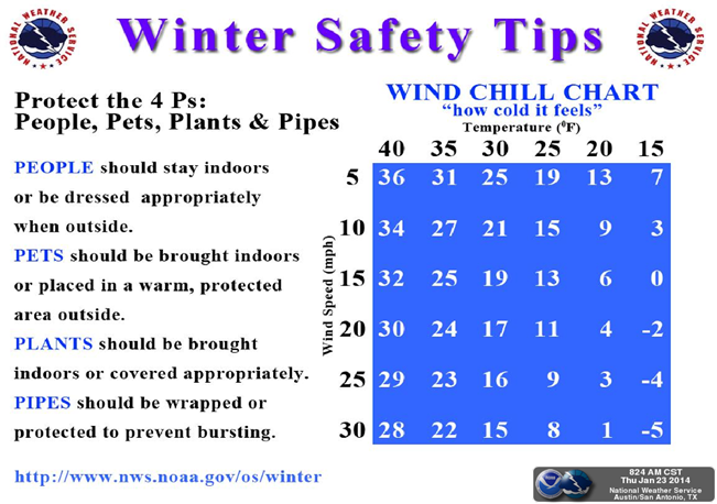
* Protect pipes, plants, people, and pets from freezing conditions.
* Limit outdoor activities and take frequent breaks to warm-up; dress in layers.
* Use caution on roadways, as there may be slick spots on rural roads, bridges,
overpasses, and other areas.
Resources:
* National Weather Service - San Antonio: http://www.weather.gov/austin
* UTSA Campus Alerts Webpage:
www.alerts.utsa.edu<http://www.alerts.utsa.edu> - Monitor the Campus Alerts website
for the latest information on campus operations.
* 458-SNOW (7669): The hotline has been updated and will continue to be as
conditions warrant.
* Street Closures:
http://www.sanantonio.gov/public-works/emergencystreetclosures.aspx
Please forward this information to your department stakeholders. Thanks!
[cid:part3.05040503.06030004@noaa.gov]
______________________________
Lorenzo D. Sanchez, MPA, CEM
Director of Emergency Management
The University of Texas at San Antonio
University Police Department
Office of Emergency Management
One UTSA Circle
San Antonio, Texas 78249
Phone: (210) 458-6756
Fax: (210) 458-7602
Email: lorenzo.sanchez@utsa.edu<mailto:lorenzo.sanchez@utsa.edu>
Website: www.utsa.edu/utsapd<http://www.utsa.edu/utsapd>
Campus Alerts: http://alerts.utsa.edu/
[cid:image001.jpg@01CD17CE.5E7D8A80]<http://www.utsa.edu/>[Facebook]<http://www.facebook.com/UTSAPoliceDepartment>[Twitter]<http://twitter.com/UTSA_Police>
From: Jon Zeitler [mailto:jon.zeitler@noaa.gov]
Sent: Thursday, January 23, 2014 3:37 PM
Subject: Issued 345 pm Thu 23 Jan 2014 : Winter Weather Event Outlook for Tonight/Friday
South Central Texas Partners...
***No significant change in the forecast from earlier today, but a new graphic for tonight
below***
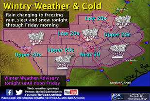
...HEADLINE...A mix of light sleet, snow, and freezing rain, across all of South Central
Texas, mainly from from 6 pm Tonight to noon Friday.
...AREA OF CONCERN...Light winter precipitation accumulation on elevated surfaces, mostly
north of a line from Del Rio to San Antonio to Schulenburg. A wintry mix is expected
elsewhere (Rio Grande and Coastal Plains) but we are not looking for significant
accumulation at this time.
...IMPACTS...Light icing from freezing rain, sleet, and snow, mainly on bridges and
overpasses, and on anything else where the cold air will cool the object to the air
temperature (e.g., car roofs and windshields). Roads will generally be ok since the warm
ground will melt the falling precipitation. However, less traveled roads in the Hill
Country and Williamson County could also see some light accumulations and icy conditions.
The commute on Friday morning may be significantly impacted. Cold temperatures will be in
place Tonight and Friday morning, with readings in the 20s and low 30s. The high
temperatures Friday will only be in the upper 30s to lower 40s.
...TIMING...some mixed precipitation could start in the Hill Country by late afternoon,
but mainly 6 pm Tonight to Noon Friday for the entire area.
...DISCUSSION...
The Arctic cold front ran a few hours late, but has now moved through South Central Texas.
High temperatures Today have already occurred, and will fall through the day as the cold
air keeps pouring in behind the front. A weak disturbance will move across Texas Tonight
into Friday. While precipitation will be light, the forecast models indicate winter
precipitation starting late this afternoon in the Hill Country, and spreading southeast
Tonight into Friday. Temperatures are expected to fall below freezing across all of South
Central Texas before midnight Friday morning.
We expect a mix of sleet, freezing rain, and snow, with accumulation mainly across the
northern half of the area...north of a line from Del Rio...to San Antonio...to
Schulenburg. This best chances to see accumulations are in the Hill Country and Williamson
County where we are currently forecasting up to 1 inch of accumulation of snow. Other
areas should only see a dusting. Temperatures are expected to climb above freezing by
Friday afternoon so if this event does occur...it should be over by midday.
Graphics for Tonight/Friday and Safety Tips are below.
You can get the latest forecasts and watches/warnings/advisories by going to the
Austin-San Antonio National Weather Service website at
www.weather.gov/austin<http://www.weather.gov/austin>
-Jon Zeitler
National Weather Service Austin-San Antonio TX
[cid:part2.04000405.09070506@noaa.gov]
[cid:image003.png@01CF1857.5D3E7770]