
3:44 p.m.
UTSA Preparedness Partners,
Please review the information [below] provided by the National Weather Service.
Thunderstorms are moving into the area and may produce hail and/or damaging winds. Please
stay informed of changing conditions by visiting the NWS website at
www.weather.gov/sanantonio<http://www.weather.gov/sanantonio>;.
Have a good day!
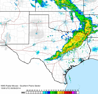
Current Radar:
[South Plains sector]
______________________________
Lorenzo D. Sanchez, MPA, CEM
Director of Emergency Management
The University of Texas at San Antonio
University Police Department
Office of Emergency Management
One UTSA Circle
San Antonio, Texas 78249
Phone: (210) 458-6756
Fax: (210) 458-7602
Email: lorenzo.sanchez@utsa.edu<mailto:lorenzo.sanchez@utsa.edu>
Website: www.utsa.edu/utsapd<http://www.utsa.edu/utsapd>
Campus Alerts: http://alerts.utsa.edu/
From: Joe.Arellano [mailto:joe.arellano@noaa.gov]
Sent: Monday, June 09, 2014 10:07 AM
Subject: 10 AM Monday 9 June --Severe Weather Outlook
South Central Texas Partners...
...HEADLINE...Scattered showers and thunderstorms from today through midday Tuesday.
Slight Chance of severe storms today and into this evening across all of South Central
Texas.
...AREA OF CONCERN...The best chance for severe storms will be over central and eastern
portions of South Central Texas, mainly east of Highway 83. This includes the Austin and
San Antonio metro areas.
...IMPACTS...The most likely severe threat is large hail, with a secondary threat of
damaging winds. Locally heavy rains could also cause minor flash flooding of low water
crossings and other typical low spots may occur. There is almost no chance of tornadoes.
Rainfall will average 1/2 inch or less with a a few spots could get up to 1-2 inches in a
short period of time causing minor flooding.
...TIMING...Scattered showers and thunderstorms are moving across the Texas Hill Country
this morning and will continue to move eastward throughout today. The best chance for
severe storms will be from Noon to 9 pm today.
...CONFIDENCE...Moderate.
...DISCUSSION...A weak cold front will continue to sag south across Central Texas and end
up along Interstate 10 by this afternoon. Meanwhile, an upper level trough will arrive
about the same time, and when combined with the front and moist, Gulf air already in
place, produce showers and thunderstorms. There is enough wind shear and instability for
severe storms, with primary threats of damaging winds and large hail. Some hail could be
golf ball-size or larger. The trough will pass to the east on Tuesday, with rain chances
ending quickly from west to east Tuesday.
You can see the latest forecasts and watches/warnings/advisories by going to the
Austin-San Antonio National Weather Service website at
www.weather.gov/austin<http://www.weather.gov/austin>
Joe Arellano
Meteorologist In Charge
National Weather Service - Austin/San Antonio
--
[cid:part2.02040604.04090006@noaa.gov]
4316
days inactive
4316
days old
0 comments
1 participants
participants (1)
-
 advising@lists.sis.utsa.edu