
2:50 p.m.
FYI
From: Linda Mahoney
Sent: Thursday, January 23, 2014 8:37 AM
To: Becky Sanchez; Agustin Llano; Alan Vince; Alfred Silva; Barbara Smith; Gail Pizzola;
Joleen Reynolds; Leticia Duncan; Lisa Buentello; Nancy Martin; Tammy Wyatt; Tricia
Kobberdahl
Cc: Lawrence Williams; Monica Lucero; Irene Coad; Janet Allen-Mcconkey; Margaret Garcia
Subject: EM Alert: Winter Weather Outlook - Thursday & Friday
Importance: High
FYI
From: Debbie (Howard) Rappaport
Sent: Thursday, January 23, 2014 8:34 AM
Subject: FW: EM Alert: Winter Weather Outlook - Thursday & Friday
Importance: High
Please forward this information to your faculty and staff.
Thanks,
Debbie
Debbie Howard
Executive Assistant
The University of Texas at San Antonio
debbie.howard@utsa.edu<mailto:debbie.howard@utsa.edu>
From: Lorenzo Sanchez
Sent: Wednesday, January 22, 2014 4:30 PM
To: Be Prepared
Subject: EM Alert: Winter Weather Outlook - Thursday & Friday
Importance: High
UTSA Preparedness Partners,
A strong arctic front will be moving into the San Antonio metro Thursday morning (7 - 8
am), bringing with it blustery, chilly, and wintry conditions. Beginning Thursday,
temperatures will drop from the mid-40's during the morning rush hour to below
freezing as the day progresses. At this time, the National Weather Service (NWS)
continues to warn of the possibility for a wintry mix of light sleet and snow developing
Thursday evening around 6:00 pm, with a continued chance through noon on Friday.
Precipitation totals of sleet/snow within city limits will range from a trace to a quarter
of an inch, and areas north of 1604 may see between a quarter to a half inch;
accumulations will be minimal. Elevated surfaces, such as bridges, overpasses, fly-overs,
walkways, and concrete surfaces are areas of concern. Ground level areas may remain warm
enough to melt any frozen precipitation. A Winter Storm Watch has been issued for our
area from midnight to noon on Friday.
Preparedness and Recommendations:
* UTSA Emergency Operations Center: Activated to a level III - monitoring and
assessment.
* UTSA Departments: Secure sensitive equipment from freezing conditions if stored
outside or in vulnerable areas. Monitor the Campus Alerts website over the next 48
hours.
* UTSA Facilities: UTSA is in a state of readiness, and will implement components
of the ice plan as necessary to keep university roads and walkways safe.
* Protect pipes, plants, people, and pets from freezing conditions.
* Limit outdoor activities and take frequent breaks to warm-up; dress in layers.
* Use caution on roadways, as there may be slick spots on rural roads, bridges,
overpasses, and other areas.
Resources:
* National Weather Service - San Antonio: http://www.weather.gov/austin
* UTSA Campus Alerts Webpage:
www.alerts.utsa.edu<http://www.alerts.utsa.edu> - Monitor the Campus Alerts website
for the latest information on campus operations.
* 458-SNOW (7669): The hotline has been updated and will continue to be as
conditions warrant.
* Street Closures:
http://www.sanantonio.gov/public-works/emergencystreetclosures.aspx
Please forward this information to your department stakeholders. Additional updates will
be provided on Thursday - see the full NWS discussion in the email below. Thanks!
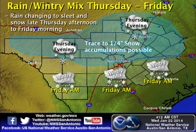
THURSDAY EVENING - FRIDAY
[http://www.srh.noaa.gov/images/fxc/ewx/graphicast/image4.png]<http://w...
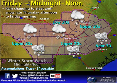
FRIDAY MIDNIGHT - NOON
[cid:image005.png@01CF178F.269D5100]
______________________________
Lorenzo D. Sanchez, MPA, CEM
Director of Emergency Management
The University of Texas at San Antonio
University Police Department
Office of Emergency Management
One UTSA Circle
San Antonio, Texas 78249
Phone: (210) 458-6756
Mobile: (210) 464-5793
Fax: (210) 458-7602
Email: lorenzo.sanchez@utsa.edu<mailto:lorenzo.sanchez@utsa.edu>
Website: www.utsa.edu/utsapd<http://www.utsa.edu/utsapd>
Campus Alerts: http://alerts.utsa.edu/
[cid:image002.jpg@01CCA43F.6C374C40]
******
From: Jon Zeitler [mailto:jon.zeitler@noaa.gov]
Sent: Wednesday, January 22, 2014 4:05 PM
Subject: Issued 400 pm Wed 22 Jan 2014 : Winter Weather Event Outlook for Thursday/Friday
South Central Texas Partners...
...HEADLINE...A mix of light sleet, snow, and freezing rain, across all of South Central
Texas from 6 pm Thursday to 2 pm Friday.
...AREA OF CONCERN...Winter precipitation accumulations on elevated surfaces north of a
line from Del Rio to San Antonio to Schulenburg. A wintry mix is expected elsewhere (Rio
Grande and Coastal Plains) but we are not looking for significant accumulations at this
time.
...IMPACTS...Light icing from sleet and snow mainly on bridges and overpasses, and
anything where the object will be the same as the air temperature (e.g., car roofs and
windshields). Roads will generally be ok since the warm ground will melt the falling
precipitation. However, less traveled roads in the Hill Country and Williamson County
could also see some light accumulations and icy conditions. The late evening commute
(after 6 pm) could be impacted Thursday evening. The morning commute on Friday morning
will be significantly impacted. Cold temperatures will be in place Thursday and
Friday...with highs only in the 30s to low 40s and wind chills in the teens and low 20s.
...TIMING...Mainly 6 pm Thursday to Noon Friday. Some concern in the Coastal Plains east
of I-35 until 2 pm Friday afternoon.
...DISCUSSION...
Another Arctic cold front will move through South Central Texas a few hours either side of
sunrise Thursday morning. High temperatures on Thursday will occur during the morning,
then temperatures fall through the day as the cold air moves in, staying in the 30s and
40s during the afternoon. A weak disturbance will move out of the Rockies and across
Texas Thursday night into Friday. While precipitation will be light, the forecast models
match our experience with these systems, indicating winter precipitation starting Thursday
afternoon in the Hill Country, and spreading southeast Thursday night into Friday.
Temperatures are expected to fall below freezing across all of South Central Texas before
midnight Friday morning.
We expect a mix of sleet and snow, with accumulation mainly across the northern half of
the area...north of a line from Del Rio...to San Antonio...to Schulenburg. This best
chances to see accumulations are in the Hill Country and Williamson County where we are
currently forecasting around 1 inch of accumulation of snow. Other areas should only see
a dusting. Temperatures are expected to climb above freezing by Friday afternoon so if
this event does occur...it should be be quickly gone by the afternoon.
Graphics for Thursday and Friday are below.
You can get the latest forecasts and watches/warnings/advisories by going to the
Austin-San Antonio National Weather Service website at
www.weather.gov/austin<http://www.weather.gov/austin>
-Jon Zeitler
National Weather Service Austin-San Antonio TX
[cid:image004.jpg@01CF178C.A3CD1320]
![http://www.srh.noaa.gov/images/fxc/ewx/graphicast/image4.png]<http://w...](http://www.srh.noaa.gov/images/fxc/ewx/graphicast/image4.png]%3Chttp://www.srh.noaa.gov/graphicast.php?site=ewx&gc=4%3E)
4451
days inactive
4451
days old
0 comments
1 participants
participants (1)
-
 advising@lists.sis.utsa.edu