
10:32 p.m.
From: Lorenzo Sanchez
Sent: Monday, January 27, 2014 4:24 PM
To: Be Prepared
Subject: EM Alert: Winter Weather Outlook - Tonight through mid-Tuesday
Importance: High
UTSA Preparedness Partners,
Another strong arctic front has pushed through the San Antonio metro this morning,
bringing with it blustery, chilly, and possibly wintry conditions in the overnight hours.
The current temperature at UTSA is 46, and will continue to fall below freezing by 9 pm
tonight. At this time, the National Weather Service (NWS) warns of the possibility (20%
chance) for a wintry mix of light freezing rain, sleet, and snow from midnight (tonight)
through 10 a.m. on Tuesday. Elevated surfaces, such as bridges, overpasses, fly-overs,
walkways, and concrete surfaces are areas of concern. A Winter Weather Advisory has been
issued for our area beginning at midnight tonight through noon Tuesday. My apologies for
the quick notice on this event, but conditions with this frontal system escalated very
quickly.
Preparedness and Recommendations:
* UTSA Emergency Management: Remains in close communication with local public
safety partners, National Weather Service, TxDOT, school districts, and City/County
organizations. Emergency Operations Center is monitoring weather conditions.
* UTSA Departments: Secure sensitive equipment from freezing conditions if stored
outside or in vulnerable areas. Update call trees and related weather procedures; share
with staff and faculty. Monitor the Campus Alerts website
(www.alerts.utsa.edu<http://www.alerts.utsa.edu>;) and 458-SNOW (7669).
* UTSA Facilities: UTSA is in a state of readiness, and will implement components
of the ice plan as necessary to keep university roads and walkways safe.
* UTSA Police: Monitoring roadways, bridges, access roads, and are ready to deploy
barriers if necessary. Access Control remains on standby for assistance.
* Protect pipes, plants, people, and pets from freezing conditions.
* Limit outdoor activities and take frequent breaks to warm-up; dress in layers.
* Use caution on roadways, as there may be slick spots on rural roads, bridges,
overpasses, and other areas.
Resources:
* National Weather Service - San Antonio: http://www.weather.gov/austin
* UTSA Campus Alerts Webpage:
www.alerts.utsa.edu<http://www.alerts.utsa.edu> - Monitor the Campus Alerts website
for the latest information on campus operations.
* 458-SNOW (7669): The hotline has been updated.
* Street Closures:
http://www.sanantonio.gov/public-works/emergencystreetclosures.aspx
Please forward this information to your department stakeholders. Thanks!
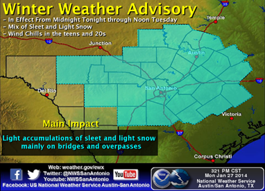
WINTER WEATHER ADVISORY:
[Description:
http://www.srh.noaa.gov/images/fxc/ewx/graphicast/image3.png]<http://w...
TONIGHT:
[Description:
http://www.srh.noaa.gov/images/fxc/ewx/graphicast/image2.png]<http://w...
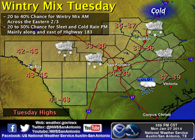
TUESDAY:
[Description:
http://www.srh.noaa.gov/images/fxc/ewx/graphicast/image5.png]<http://w...
______________________________
Lorenzo D. Sanchez, MPA, CEM
Director of Emergency Management
The University of Texas at San Antonio
University Police Department
Office of Emergency Management
One UTSA Circle
San Antonio, Texas 78249
Phone: (210) 458-6756
Fax: (210) 458-7602
Email: lorenzo.sanchez@utsa.edu<mailto:lorenzo.sanchez@utsa.edu>
Website: www.utsa.edu/utsapd<http://www.utsa.edu/utsapd>
Campus Alerts: http://alerts.utsa.edu/
[cid:image007.jpg@01CF1B7A.FEB7C450]<http://www.utsa.edu/>[cid:image008.jpg@01CF1B7A.FEB7C450]<http://www.facebook.com/UTSAPoliceDepartment>[cid:image009.jpg@01CF1B7A.FEB7C450]<http://twitter.com/UTSA_Police>
From: Jon Zeitler [mailto:jon.zeitler@noaa.gov]
Sent: Monday, January 27, 2014 4:10 PM
Subject: Issued 415 pm Mon 27 Jan 2014 : Winter Weather Event Outlook for Tonight
South Central Texas Partners...
...HEADLINE...A Winter Weather Advisory is in effect for a mix of sleet and snow, mainly
from midnight through noon Tuesday.
...AREA OF CONCERN...Along and east of U.S. 83, including all of the I-35 Corridor,
Austin, and San Antonio.
...IMPACTS...Arctic air continues to pour into the region, causing temperatures to
continue falling. Temperatures should fall below freezing around 9-10 pm, followed by a
chance of precipitation starting around midnight. Since temperatures will be below
freezing, we expect a mix of light sleet and snow through 10 am Tuesday, then mixed with
some rain before ending around noon Tuesday. The main concern will be slippery spots on
bridges, other elevated roadways, and any object air can get underneath (e.g., cars,
decks). Temperatures around sunrise will range from the mid 20s to low 30s, and combined
with the wind, will produce wind chills from the teens to lower 20s.
...TIMING...Midnight to noon Tuesday.
...DISCUSSION...
An upper level low will move across Texas tonight and early Tuesday, bringing a slight
chance for precipitation. We expect a mix of light sleet and snow from midnight to 10 am
Tuesday, then mixing with rain until the precipitation ends around noon. While
temperatures will be cold enough for wintry precipitation, coverage will be scattered and
amounts light, so only minor travel impacts are expected at this time. Temperatures will
remain above freezing Tuesday afternoon, which should melt and evaporate any sleet or snow
that fell in the morning. However, expect the cold to continue into Tuesday night, with
temperatures in the teens in the Hill Country, and lower to mid 20s elsewhere. A warming
trend with start Wednesday afternoon with highs in the mid to upper 40s, with 70s
returning by the weekend.
You can get the latest forecasts and watches/warnings/advisories by going to the
Austin-San Antonio National Weather Service website at
www.weather.gov/austin<http://www.weather.gov/austin>
-Jon Zeitler
National Weather Service Austin-San Antonio TX
[cid:part2.09010701.07050800@noaa.gov]
![http://www.srh.noaa.gov/images/fxc/ewx/graphicast/image3.png]<http://w...](http://www.srh.noaa.gov/images/fxc/ewx/graphicast/image3.png]%3Chttp://www.srh.noaa.gov/graphicast.php?site=ewx&gc=3%3E)
![http://www.srh.noaa.gov/images/fxc/ewx/graphicast/image2.png]<http://w...](http://www.srh.noaa.gov/images/fxc/ewx/graphicast/image2.png]%3Chttp://www.srh.noaa.gov/graphicast.php?site=ewx&gc=2%3E)
![http://www.srh.noaa.gov/images/fxc/ewx/graphicast/image5.png]<http://w...](http://www.srh.noaa.gov/images/fxc/ewx/graphicast/image5.png]%3Chttp://www.srh.noaa.gov/graphicast.php?site=ewx&gc=5%3E)
4447
days inactive
4447
days old
0 comments
1 participants
participants (1)
-
 advising@lists.sis.utsa.edu