
10:49 p.m.
From: Lorenzo Sanchez
Sent: Thursday, February 06, 2014 4:42 PM
To: Be Prepared
Subject: EM Alert 2: Round Two of Winter Weather Tonight/Friday Morning
UTSA Preparedness Partners,
Thanks for your continued support. As many of you are aware, the north side of San
Antonio experienced a light band of wintry mix, mostly in the form or snow pellets known
as "graupel." By definition, graupel refers to precipitation that forms when
super-cooled droplets of water are collected and freeze on a falling snowflake. This
morning's event was not widespread across the city, rather was concentrated on the
north side, hence why most of the highways and roadways across the city were dry and
clear. 1604 North became quite a traffic mess, and thank you for your patience dealing
with those issues.
With this morning system out of the area, we are awaiting another system (part 2) to enter
our area in the overnight hours. With freezing temperatures in place, tomorrow's
weather will be variable and difficult to forecast. The following will summarize National
Weather Service predictions -
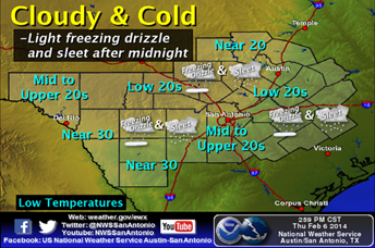
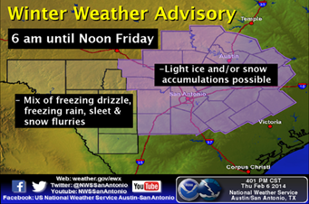
Thursday Overnight/Friday Morning: We will again hit freezing overnight with another
chance of freezing drizzle, sleet, snow, and/or ice after midnight - noon Friday. During
this timeframe, the NWS is elevating the chance of frozen precipitation to 30-40% as an
approaching weather system enters Texas. Should a wintry mix develop, light accumulations
are possible due to frigid conditions. Roadways and elevated surfaces may be impacted
depending on the amount and type of frozen precipitation - use caution on roadways.
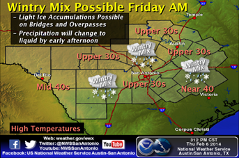
Temperatures will remain in the lower 30's through noon, and gradually rebound as the
day progresses. The NWS will provide additional updates as models become clearer.
Preparedness and Recommendations:
* UTSA Emergency Management: Remains in close communication with local public
safety partners, National Weather Service, TxDOT, school districts, and City/County
organizations. Emergency Operations Center is monitoring weather conditions.
* University Communications: Providing support to update websites, weather
hotlines, social media, and communications with campus stakeholders.
* UTSA Departments: Secure sensitive equipment from freezing conditions if stored
outside or in vulnerable areas. Update call trees and related weather procedures; share
with staff and faculty. Monitor the Campus Alerts website
(www.alerts.utsa.edu<http://www.alerts.utsa.edu>;) and 458-SNOW (7669).
* UTSA Facilities: UTSA is in a state of readiness, and will implement components
of the ice plan as necessary to keep university roads and walkways safe.
* UTSA Police: Monitoring roadways, bridges, access roads, and are ready to deploy
barriers if necessary.
* Protect pipes, plants, people, and pets from freezing conditions.
* Limit outdoor activities and take frequent breaks to warm-up; dress in layers.
* Use caution on roadways, as there may be slick spots on rural roads, bridges,
overpasses, and other areas.
* UTSA community should monitor the Campus Alerts website, 458-SNOW (7669), and
social media for updates on university operations.
Resources:
* National Weather Service - San Antonio: http://www.weather.gov/austin
* UTSA Campus Alerts Webpage:
www.alerts.utsa.edu<http://www.alerts.utsa.edu> - Monitor the Campus Alerts website
for the latest information on campus operations.
* 458-SNOW (7669): The hotline has been updated.
* Street Closures:
http://www.sanantonio.gov/public-works/emergencystreetclosures.aspx
* Highway Conditions: http://www.drivetexas.org/Full/
Please forward this information to your department stakeholders. See the full NWS weather
discussion below. Thanks and be safe!
TONIGHT:
[http://www.srh.noaa.gov/images/fxc/ewx/graphicast/image2.png]<http://w...
WINTER WEATHER ADVISORY:
[http://www.srh.noaa.gov/images/fxc/ewx/graphicast/image1.png]<http://w...
FRIDAY:
[http://www.srh.noaa.gov/images/fxc/ewx/graphicast/image4.png]<http://w...
______________________________
Lorenzo D. Sanchez, MPA, CEM
Director of Emergency Management
The University of Texas at San Antonio
University Police Department
Office of Emergency Management
One UTSA Circle
San Antonio, Texas 78249
Phone: (210) 458-6756
Mobile: (210) 464-5793
Fax: (210) 458-7602
Email: lorenzo.sanchez@utsa.edu<mailto:lorenzo.sanchez@utsa.edu>
Website: www.utsa.edu/utsapd<http://www.utsa.edu/utsapd>
Campus Alerts: http://alerts.utsa.edu/
[cid:image002.jpg@01CCA43F.6C374C40]
From: Paul Yura [mailto:paul.yura@noaa.gov]
Sent: Thursday, February 06, 2014 2:50 PM
Subject: 245 PM Weather update....chances continue for frozen precipitation starting late
tonight through Friday.
South Central Texas Partners....
...HEADLINE...Additional sleet/freezing drizzle/snow again late tonight into Friday...
...AREA OF CONCERN...All of South Central Texas but mainly east of a line from Leakey down
to Carrizo Springs (Highway 83).
...IMPACTS...Late Tonight (after midnight) and Friday...light ice accumulation possible on
bridges and overpasses and some roads. Road impacts will be highly dependent on type of
precipitation and intensity. Exposed surfaces where cold air can get underneath (e.g.,
cars, decks) may see a light glazing of ice. Travel may get impacted, but no other impacts
(power outages, trees down) expected. Arctic air will maintain cold temperatures across
the region with a freeze expected overnight...while high temperatures on Friday could stay
in the 30s all day once again.
...TIMING...Another round of winter precipitation could form during the overnight hours
(starting mainly after midnight) and continuing at least through through noon on Friday.
There are some indications that light precipitation could continue across the eastern half
of the area into the afternoon hours. If the temperatures stay cold enough, frozen
precipitation could occur into early afternoon.
...DISCUSSION...
The chances for freezing drizzle/sleet/snow are possible overnight (after midnight)
Thursday into Friday as another upper level disturbance moves across Texas from the West.
We have increased overall chances of frozen precipitation just a bit as some of the
weather models are creating a better overall chance of seeing some light precipitation
through mid day on Friday. Temperatures will definitely be cold enough to support frozen
precipitation, confidence is low at the is point as to whether it will be freezing
drizzle, sleet, snow, or these snow pellets like we saw this morning across the central
sections of South Central Texas. In fact we may see reports of all those precipitation
types on Friday. If precipitation does form, there would likely be travel impacts Friday
morning, possibly lasting through early afternoon. Temperatures will remain very cold on
Friday...struggling to get into the mid and upper 30s by late afternoon across the
northern half of the area...some 40s are expected along the Rio Grande and southern half
of the area. Any frozen precipitation that does fall will be very slow to melt and could
in fact keep temperatures near freezing all day on Friday, similar to what we are seeing
now.
Overall confidence that freezing temperatures will be in place is very HIGH. Overall
confidence on the amount of precipitation is again low. As we have seen over the past
week or so, its not taking much lift to create the frozen precipitation. We even had
lightning and thunder here in New Braunfels with the frozen precipitation this morning,
which helped to create quick bursts of precipitation and led to some accumulations on the
ground and roads. Weather models have performed very poorly with these last few events
and our confidence in them is rather low at this point. So judging from what the past
few "disturbances" have brought to the area, all of South Central Texas needs to
be ready to respond to frozen precipitation Friday morning into the early afternoon hours.
Most of the impacts will be travel related with light icing possible on the bridges,
overpasses, some roads, as well as icing on exposed surfaces. Reporting and good
situational awareness is key. Road crews may be busy once again.
Check the forecast frequently as Winter Weather Advisories may be issued. You can monitor
by going to our webpage for the latest forecasts and watches/warnings/advisories from the
Austin-San Antonio National Weather Service.
www.weather.gov/austin<http://www.weather.gov/austin>
Depending on conditions, the next email could be issued overnight and/or on Friday.
Paul Yura
National Weather Service Austin-San Antonio.
--
[cid:part2.07040905.01000603@noaa.gov]
![http://www.srh.noaa.gov/images/fxc/ewx/graphicast/image2.png]<http://w...](http://www.srh.noaa.gov/images/fxc/ewx/graphicast/image2.png]%3Chttp://www.srh.noaa.gov/graphicast.php?site=ewx&gc=2%3E)
![http://www.srh.noaa.gov/images/fxc/ewx/graphicast/image1.png]<http://w...](http://www.srh.noaa.gov/images/fxc/ewx/graphicast/image1.png]%3Chttp://www.srh.noaa.gov/graphicast.php?site=ewx&gc=1%3E)
![http://www.srh.noaa.gov/images/fxc/ewx/graphicast/image4.png]<http://w...](http://www.srh.noaa.gov/images/fxc/ewx/graphicast/image4.png]%3Chttp://www.srh.noaa.gov/graphicast.php?site=ewx&gc=4%3E)
4439
days inactive
4439
days old
0 comments
1 participants
participants (1)
-
 advising@lists.sis.utsa.edu