
6:10 p.m.
From: Lorenzo Sanchez
Sent: Monday, March 03, 2014 9:23 AM
To: Be Prepared
Subject: EM Alert: Winter Weather Advisory & Possible Icy Conditions Tonight/Tuesday
Morning
Importance: High
UTSA Preparedness Partners,
Winter isn't letting go just yet, whereby an arctic air mass has settled over our area
bringing with it blustery conditions. Cold temperatures, paired with increasing
precipitation chances, will usher in the threat for icy conditions beginning this evening
(8:00 pm - Midnight), reaching peak intensity around sunrise Tuesday morning. Freezing
temperatures are expected shortly after sunset today through mid-morning Tuesday. A
Winter Weather Advisory has been issued for the San Antonio metro from 8:00 pm tonight
through 12:00 pm Tuesday. I will provide updated information after a briefing with the
National Weather Service this afternoon.
Preparedness and Recommendations:
* UTSA Emergency Management: Remains in close communication with local public
safety partners and the National Weather Service.
* UTSA Departments: Secure sensitive equipment from freezing conditions if stored
outside or in vulnerable areas. Update call trees and related weather procedures; share
with staff and faculty. Monitor the Campus Alerts website
(www.alerts.utsa.edu<http://www.alerts.utsa.edu>;) and 458-SNOW (7669).
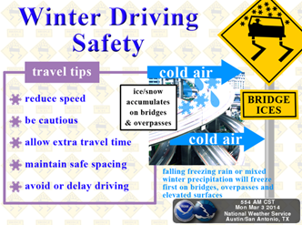
* Protect pipes, plants, people, and pets from freezing conditions.
* Limit outdoor activities and take frequent breaks to warm-up; dress in layers.
* Use caution on roadways, as there may be slick spots on rural roads, bridges,
overpasses, and other areas.
Resources:
* National Weather Service - San Antonio: http://www.weather.gov/austin
* UTSA Campus Alerts Webpage:
www.alerts.utsa.edu<http://www.alerts.utsa.edu> - Monitor the Campus Alerts website
for the latest information on campus operations.
* Street Closures:
http://www.sanantonio.gov/public-works/emergencystreetclosures.aspx
* Highway Conditions: http://www.drivetexas.org/Full/
Please forward this information to your department stakeholders. The full NWS discussion
is below. Thanks and be safe!
TONIGHT:
[Description:
http://www.srh.noaa.gov/images/fxc/ewx/graphicast/image2.png]<http://w...:
http://www.srh.noaa.gov/images/fxc/ewx/graphicast/image5.png]<http://w...
______________________________
Lorenzo D. Sanchez, MPA, CEM
Director of Emergency Management
The University of Texas at San Antonio
University Police Department
Office of Emergency Management
One UTSA Circle
San Antonio, Texas 78249
Phone: (210) 458-6756
Fax: (210) 458-7602
Email: lorenzo.sanchez@utsa.edu<mailto:lorenzo.sanchez@utsa.edu>
Website: www.utsa.edu/utsapd<http://www.utsa.edu/utsapd>
Campus Alerts: http://alerts.utsa.edu/
[Description: cid:image001.jpg@01CD17CE.5E7D8A80]<http://www.utsa.edu/>[Description:
Facebook]<http://www.facebook.com/UTSAPoliceDepartment>[Description:
Twitter]<http://twitter.com/UTSA_Police>
From: Jon Zeitler [mailto:jon.zeitler@noaa.gov]
Sent: Monday, March 03, 2014 5:05 AM
Subject: Winter Weather Forecast from NWS : Issued 500 am Mon Mar 3
South Central Texas Partners....
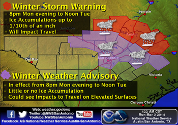
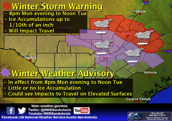
...HEADLINE...A Winter Storm Warning has been issued for locations along and north of
Texas 71...and a Winter Weather Advisory has been issued for locations south of Texas 71
but along/north of Interstate 10.
...AREA OF CONCERN...The entire area along and north of Interstate 10, including Metro San
Antonio. Special concern for areas along and north of Texas 71 including Metro Austin. If
Texas 71 or Interstate 10 pass through the county where your home, business, or
jurisdiction is located, assume the entire county has the potential for winter weather
tonight into Tuesday morning.
...IMPACTS...Light ice accumulation possible on bridges, flyovers, and some roads in the
Winter Weather Advisory area. Exposed surfaces where cold air can get underneath (e.g.,
cars, decks) may also see light icing. More significant impacts in the Winter Storm
Warning area, including the possibility of many roads ice covered. No major other damage
(e.g., tree or power line damage) is expected, but sensitive plants should be covered, and
people and pets plan on spending tonight indoors. Thundersleet and thunder with freezing
rain are possible. There is no threat for the Monday evening commute. There is a high
likelihood of major impact on the Tuesday morning commute. There is no threat for the
Tuesday evening commute.
...TIMING...Temperatures will barely rise to the upper 30s to lower 40s across the
Warning and Advisory areas this afternoon, then quickly fall below freezing after sunset.
Precipitation is expected to start between 8 pm and midnight, reaching peak intensity
around sunrise Tuesday, then taper off by mid-morning Tuesday. Temperatures will warm
above freezing by noon Tuesday, and melting of any ice on roads should be quick.
...DISCUSSION...
Another Arctic air mass is in place across South Central Texas. Moist Gulf air will lift
over the cold air, and combined with an upper level trough should produce rain that will
quickly mix and changeover to freezing rain and sleet. Significant accumulation of the
freezing rain and sleet is expected along and north of Texas 71, including Metro Austin.
Roads may be treacherous from midnight through noon Tuesday.
Our confidence that freezing temperatures will be in place is 100%. Our confidence on the
amount of precipitation is MODERATE to HIGH. South Central Texas needs to be ready to
respond again to frozen precipitation. Again, the main impact will be on travel, with
icing possible (Advisory area) and likely (Warning area), especially on bridges, flyovers,
and lightly traveled roads.
You can monitor the latest forecasts and watches/warnings/advisories from the Austin-San
Antonio National Weather Service on our webpage:
www.weather.gov/austin<http://www.weather.gov/austin>
-Jon Zeitler
National Weather Service Austin-San Antonio
[cid:part2.07000502.02010708@noaa.gov]
[cid:image011.png@01CF36C2.1CB60540]
![http://www.srh.noaa.gov/images/fxc/ewx/graphicast/image2.png]<http://w...](http://www.srh.noaa.gov/images/fxc/ewx/graphicast/image2.png]%3Chttp://www.srh.noaa.gov/graphicast.php?site=ewx&gc=2%3E%5BDescription)
![http://www.srh.noaa.gov/images/fxc/ewx/graphicast/image5.png]<http://w...](http://www.srh.noaa.gov/images/fxc/ewx/graphicast/image5.png]%3Chttp://www.srh.noaa.gov/graphicast.php?site=ewx&gc=5%3E)
4413
days inactive
4413
days old
0 comments
1 participants
participants (1)
-
 advising@lists.sis.utsa.edu