
5:28 p.m.
From: Lorenzo Sanchez
Sent: Tuesday, June 16, 2015 11:56 AM
To: Be Prepared
Subject: EM Alert 2: Weather Update - Tropical Storm Bill
UTSA Preparedness Partners,
As of this writing, Tropical Storm Bill is making landfall on the Texas coast along
Matagorda Island near the Port O’Connor area. As the system moves inland this
afternoon/evening, the center of circulation is anticipated to stay to our east – see
attachments. To summarize what we may expect, including timelines for the SA metro:
· Timeline: Center of circulation should be to our due east around 7-8 pm; in
Austin around 1 am.
· Winds will increase slightly as the storm nears to around 15 – 20 mph;
occasional higher gusts with associated rain bands.
· Rainfall totals through Thursday: 3+ inches (isolated 6+ inches).
· Flash flood watch remains in effect through 1 pm on Thursday.
UTSA Departments with outdoor activities and programs should implement contingency plans
if conditions warrant, particularly this evening. Please monitor the National Weather
Service website at www.weather.gov/sanantonio<http://www.weather.gov/sanantonio> for
the latest radar information and warnings. Additionally, do not attempt to drive through
low-water crossings; seek alternate routes – turn around, don’t drown.
Resources:
· National Hurricane Center: www.nhc.noaa.gov<http://www.nhc.noaa.gov>
· National Weather Service – San Antonio:
www.weather.gov/sanantonio<http://www.weather.gov/sanantonio>
· Street Closures:
http://www.sanantonio.gov/public-works/emergencystreetclosures.aspx
· CPS Power Outages:
http://outagemap.cpsenergy.com/CPSStaticMapsEXT/CPSStaticMapV2_EXT.html
· UTSA Campus Alerts Website:
www.alerts.utsa.edu<http://www.alerts.utsa.edu>
The full briefing is below and graphics are attached. Please let me know if you have any
questions. Thanks!
______________________________
Lorenzo D. Sanchez, MPA, CEM
Director of Emergency Management
The University of Texas at San Antonio
University Police Department
Office of Emergency Management
One UTSA Circle
San Antonio, Texas 78249
Phone: (210) 458-6756
Fax: (210) 458-7602
Email: lorenzo.sanchez@utsa.edu<mailto:lorenzo.sanchez@utsa.edu>
Website: www.utsa.edu/utsapd<http://www.utsa.edu/utsapd>
[Description: cid:image001.jpg@01CD17CE.5E7D8A80]<http://www.utsa.edu/>[Description:
Facebook]<http://www.facebook.com/UTSAPoliceDepartment>[Description:
Twitter]<http://twitter.com/UTSA_Police>[cid:image004.png@01D0A827....
From: paul.yura@noaa.gov<mailto:paul.yura@noaa.gov> [mailto:paul.yura@noaa.gov] On
Behalf Of SR-EWX Alert - NOAA Service Account
Sent: Tuesday, June 16, 2015 11:22 AM
Subject: Weather update...1115 AM Tuesday...TS Bill making landfall on Matagorda Island.
[Inline image 1]
Good morning South-Central Texas Partners,
Headline:
Locally Heavy Rainfall and Flooding Likely across portions of South-Central Texas today
through Thursday morning
Tropical Storm Conditions Possible across Far Eastern Areas this afternoon and evening.
Dangerous Flash Flooding remains the highest threat
Updates Since Last Briefing:
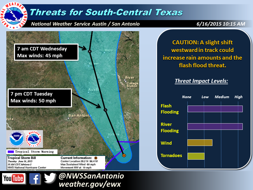
· Tropical Storm Bill at 60 mph and is making landfall along Matagorda Island.
· Partners...please stress the need for residents to remain alert this afternoon through
the overnight hours especially for those that live in low lying areas or live by
creeks/rivers. Travel this evening and overnight in the Flash Flood Watch area should be
limited to emergency travel only. A high level of awareness will need to be maintained
overnight. A landfalling tropical system after a record May rainfall can and may lead to
another record event for somebody in or near South Central Texas. Stay alert to rapidly
changing weather conditions.
Threats & Impacts:
Rainfall:
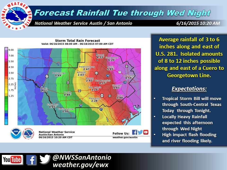
· This afternoon through Thursday morning: 3 to 6 inches of rain along and east of U.S.
281 (including Austin and San Antonio). Isolated amounts of 8 to 12 inches along and east
of an Georgetown to Cuero line. Some highly localized higher amounts towards 15" may
be possible as well. Lesser amounts of 1/4 to 1 1/2 inch across the far western Hill
Country and Rio Grande Valley.
· Heavy rainfall will likely lead to high impact flash flooding along with moderate to
major flooding of some rivers and creeks in the Flash Flood Watch area. Some locations
may experience flood waters capable of causing rivers and tributaries to overflow their
banks in several places. Small streams, creeks, canals, and ditches could become
dangerous rivers with flood waters spreading well away from the banks. Widespread
inundation of both primary and secondary roads are possible. Flood waters may prompt some
evacuations and road closures.
Wind:
· Afternoon through evening Tuesday: Tropical Storm Force winds of 30-40 mph with gusts
to 55 mph near and south of a La Grange to Gonzales line. Wind speeds of 25 to 35 mph
with gusts near 40 mph possible as far north as Austin late Tuesday afternoon and evening.
Lesser wind speeds southwest of the track.
· In the Tropical Storm Warning Area: Unsecured lightweight objects will be blown about.
Large tree limbs could be broken off. A few trees could be snapped or uprooted,
especially in areas that are saturated. Some minor damage to fences and signs are
possible.
Tornadoes:
· This afternoon into early Wednesday morning: Low chance of isolated tornadoes during
the day Tuesday east of a Burnet to New Braunfels to Cuero line. Tropical tornadoes tend
to be brief with short damage paths (EF0 and EF1).
Overview:
The latest Tropical Storm advisory has Tropical Storm Bill located right near Matagorda
Island just south of Port O'Conner with maximum sustained winds near 60 mph and moving
northwest at 10 MPH. The center of Bill will push inland over the next several hours and
is expected to follow a track into Central Texas this evening and overnight.
At this time, we are currently forecasting rainfall from this system to impact primarily
locations across the eastern Hill Country, I-35 corridor, and especially points eastward
this afternoon through Wednesday night. Overall rainfall amounts during this time frame
will likely be a widespread 3 to 6 inch swath along and east of U.S. 281 which includes
Austin and San Antonio. The greatest threat for even higher totals will be along and east
of a Georgetown to Cuero line with isolated amounts of 10 to 12 inches. It still may be
possible for even localized higher amounts in southeast and eastern locations. This heavy
rainfall will likely lead to high impact flash flooding along with moderate to major
flooding of some rivers and creeks in the Flash Flood Watch area. We are growing
increasingly concerned about heavy rainfall with the track of the storm through the area
this afternoon and evening, and even more so overnight into Wednesday morning. There is a
possibility that a heavy rainfall band could set up over a portion of the area, despite
Bill weakening and moving north of the area.
A Flash Flood Watch is in effect for central and eastern portions of the area, including
the I-35 corridor. This Flash flood watch has been expanded slightly west for more the
Hill Country and is now in effect through 1pm Thursday.
Confidence:
Heavy Rain: High
Flash Flooding: High
River Flooding: High
Tornadoes: Low
Next Briefing:
Tuesday by 5 PM
Additional Information Resources:
• NWS Austin / San Antonio Contact Numbers: 800-292-5508<tel:888-579-9731>
or 830-606-3617<tel:361-289-0725>
• NWS Austin / San Antonio Webpage: http://www.weather.gov/sanantonio
• Online Flood Reporting:
http://www.srh.noaa.gov/StormReport/SubmitReport.php?site=EWX
• Sign up to be Rainfall Observer: http://cocorahs.org/Application.aspx
• AHPS River Forecasts: http://water.weather.gov/ahps2/index.php?wfo=ewx
Request for Information:
Please relay flooding reports and/or photo’s of flooding to
sr-ewx.alert@noaa.gov<mailto:sr-ewx.alert@noaa.gov>
Sincerely,
Paul Yura
NWS Austin / San Antonio
NWS Austin / San Antonio
Weather Forecast Office
2090 Airport Road
New Braunfels, TX 78130
weather.gov/austin<http://www.weather.gov/austin>
Forecast Desk: 830-606-3617<tel:830-606-3617>
sr-ewx.alert@noaa.gov<mailto:sr-ewx.alert@noaa.gov>
[Inline image 2]
![Twitter]<http://twitter.com/UTSA_Police>[cid:image004.png@01D0A827....](http://Twitter]%3Chttp://twitter.com/UTSA_Police%3E[cid:image004.png@01D0A827.E4C0B5D0]%3Chttp://www.alerts.utsa.edu/%3E)
3944
days inactive
3944
days old
0 comments
1 participants
participants (1)
-
 advising@lists.sis.utsa.edu