
2:53 p.m.
From: Lorenzo Sanchez
Sent: Monday, May 12, 2014 9:43 AM
To: Be Prepared
Subject: EM Alert: Severe Storm Possibility and Heavy Rain/Flood Forecast from NWS
UTSA Preparedness Partners,
Please see the full forecast below provided by the National Weather Service regarding an
approaching weather system. To summarize, the SA metro may experience heavy storms this
afternoon/evening, with total rainfall between 1 - 3 inches, possibly higher in localized
areas. Strong winds and hail may be present with these storms. A flash flood watch has
been issued from 7:00 pm tonight through noon Tuesday.
Please be cautious on roadways if traveling in heavy storms, and do not attempt low-water
crossings. Stay informed of weather conditions by visiting the NWS website at
www.weather.gov/sanantonio<http://www.weather.gov/sanantonio> or local news
stations. Please let me know if you have any questions. Thanks!
______________________________
Lorenzo D. Sanchez, MPA, CEM
Director of Emergency Management
The University of Texas at San Antonio
University Police Department
Office of Emergency Management
One UTSA Circle
San Antonio, Texas 78249
Phone: (210) 458-6756
Fax: (210) 458-7602
Email: lorenzo.sanchez@utsa.edu<mailto:lorenzo.sanchez@utsa.edu>
Website: www.utsa.edu/utsapd<http://www.utsa.edu/utsapd>
Campus Alerts: http://alerts.utsa.edu/
[Description: cid:image001.jpg@01CD17CE.5E7D8A80]<http://www.utsa.edu/>[Description:
Facebook]<http://www.facebook.com/UTSAPoliceDepartment>[Description:
Twitter]<http://twitter.com/UTSA_Police>
From: Jon Zeitler [mailto:jon.zeitler@noaa.gov]
Sent: Monday, May 12, 2014 5:28 AM
Subject: 530 am Mon 5/12 -- Severe Storm and Heavy Rain/Flood Forecast from NWS
South Central Texas Partners...
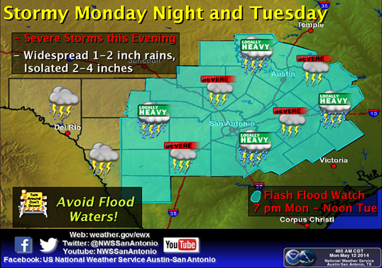
...HEADLINE...Severe storms also possible late this afternoon and evening. Flash flood
watch from 7 pm through noon Tuesday...
...AREA OF CONCERN...The entire area for severe storms late this afternoon and evening.
Then locations along and east of U.S. Highway 83 for heavy rain late tonight into Tuesday
morning.
...IMPACTS...The severe storms will have a main threat of damaging winds and a lesser
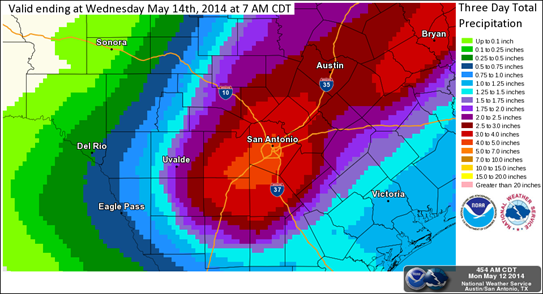
threat of large hail. Rainfall late tonight into early Tuesday will average from 1 to 3
inches east of U.S. Highway 83, with isolated spots receiving up to 5 inches.
...TIMING...The severe threat mainly from 3 pm to 10 pm. The heavy rain threat mainly
from 10 pm to 6 am, which could cause significant issues for the Tuesday morning commute.
...CONFIDENCE...High
...DISCUSSION...Moist Gulf air, an upper level trough, and a cold front will combine to
produce widespread showers and thunderstorms across the area from late this afternoon
through noon Tuesday. Severe storms are possible ahead of the front late this afternoon
through late evening. Heavy rain is possible along and behind the front late this evening
through Tuesday morning. While massive flooding is not expected, the rainfall may occur in
a 2-4 hour period, and cause significant flooding in urban areas and water rises in
north-to-south flowing rivers and creeks such as the Frio, Sabinal, and Nueces. Please
emphasize with your staff and the public to Turn Around, Don't Drown and not drive
anywhere where deep water covers the road. As usual, the rain and flooding will be
overnight, when visibility is greatly reduced. The morning commute could be difficult in
Austin and treacherous in San Antonio if the forecast rainfall occurs, as low water
crossings and low-lying spots may be flooded, and heavy rain still ongoing in San
Antonio.
The latest information is on the Austin-San Antonio National Weather Service:
Website: www.weather.gov/austin<http://www.weather.gov/austin>
Twitter: @NWSSanAntonio<https://twitter.com/NWSSanAntonio>
Facebook: US National Weather Service Austin-San Antonio
Jon Zeitler
National Weather Service Austin-San Antonio TX
[cid:part3.05030901.02080607@noaa.gov]
[cid:image004.png@01CF6DC6.90586CA0]
[cid:image005.png@01CF6DC6.90586CA0]
[cid:image006.png@01CF6DC6.90586CA0]
4344
days inactive
4344
days old
0 comments
1 participants
participants (1)
-
 advising@lists.sis.utsa.edu