
10:37 p.m.
From: Lorenzo Sanchez
Sent: Wednesday, February 05, 2014 4:35 PM
To: Be Prepared
Subject: EM Alert: Cold Weather and Possible Freezing Drizzle Thursday Morning &
Friday Morning
Importance: High
UTSA Preparedness Partners,
Thanks for your continued support. Our rollercoaster weather patterns continue, and yet
another frontal system will settle in over the SA metro tonight through Friday. This
system will be much like the second winter storm, whereby the National Weather Service is
keeping a slim chance (20%) of frozen drizzle in our forecast Thursday morning and again
Thursday evening/Friday morning. Regardless of each timeframe, little to no accumulation
of ice is expected. This is a two part event, so I will clarify by timeframe:
* Thursday Morning: Temperatures should reach freezing by 4 am Thursday, with the
slight possibility of frozen drizzle during the morning commute from 6 am - 10 am.
Additionally, winds will be out of the NE from 15 - 20 mph, with gusts from 25 - 30 mph.
Due to gusty conditions, wind chills will be in the upper teens.
* Thursday Overnight/Friday Morning: We will again hit freezing overnight
Thursday, with another [slim] chance of freezing drizzle between 2 am - 9 am.
Temperatures will rebound above freezing around 9 am Friday with a high around 43. Wind
chills will be in the low 20's.
Preparedness and Recommendations:
* UTSA Emergency Management: Remains in close communication with local public
safety partners, National Weather Service, TxDOT, school districts, and City/County
organizations. Emergency Operations Center is monitoring weather conditions.
* UTSA Departments: Secure sensitive equipment from freezing conditions if stored
outside or in vulnerable areas. Update call trees and related weather procedures; share
with staff and faculty. Monitor the Campus Alerts website
(www.alerts.utsa.edu<http://www.alerts.utsa.edu>;) and 458-SNOW (7669).
* UTSA Facilities: UTSA is in a state of readiness, and will implement components
of the ice plan as necessary to keep university roads and walkways safe.
* UTSA Police: Monitoring roadways, bridges, access roads, and are ready to deploy
barriers if necessary.
* Protect pipes, plants, people, and pets from freezing conditions.
* Limit outdoor activities and take frequent breaks to warm-up; dress in layers.
* Use caution on roadways, as there may be slick spots on rural roads, bridges,
overpasses, and other areas.
Resources:
* National Weather Service - San Antonio: http://www.weather.gov/austin
* UTSA Campus Alerts Webpage:
www.alerts.utsa.edu<http://www.alerts.utsa.edu> - Monitor the Campus Alerts website
for the latest information on campus operations.
* 458-SNOW (7669): The hotline has been updated.
* Street Closures:
http://www.sanantonio.gov/public-works/emergencystreetclosures.aspx
* Highway Conditions: http://www.drivetexas.org/Full/
Please forward this information to your department stakeholders. Thanks and be safe!
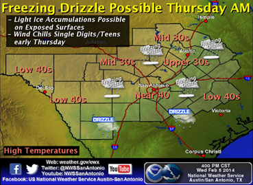
THURSDAY MORNING:
[Description:
http://www.srh.noaa.gov/images/fxc/ewx/graphicast/image3.png]<http://w...
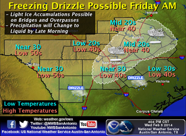
FRIDAY MORNING:
[Description:
http://www.srh.noaa.gov/images/fxc/ewx/graphicast/image4.png]<http://w...
______________________________
Lorenzo D. Sanchez, MPA, CEM
Director of Emergency Management
The University of Texas at San Antonio
University Police Department
Office of Emergency Management
One UTSA Circle
San Antonio, Texas 78249
Phone: (210) 458-6756
Fax: (210) 458-7602
Email: lorenzo.sanchez@utsa.edu<mailto:lorenzo.sanchez@utsa.edu>
Website: www.utsa.edu/utsapd<http://www.utsa.edu/utsapd>
Campus Alerts: http://alerts.utsa.edu/
[Description: cid:image001.jpg@01CD17CE.5E7D8A80]<http://www.utsa.edu/>[Description:
Facebook]<http://www.facebook.com/UTSAPoliceDepartment>[Description:
Twitter]<http://twitter.com/UTSA_Police>
***
From: Jacqueline Silva (SAFD) [mailto:Jacqueline.Silva@sanantonio.gov]
Sent: Wednesday, February 05, 2014 4:23 PM
Subject: Weather update & Situation report
________________________________
South Central Texas Partners....
...HEADLINE...Light freezing drizzle is possible Thursday morning and again Thursday night
into Friday morning.
...AREA OF CONCERN...All of South Central Texas.
...IMPACTS...
Ice accumulation...very light ice accumulation possible on bridges, overpasses (mainly
Thursday night/early Friday). Exposed surfaces such as cars, signs, etc may see a very
light glazing of ice. There is a small chance that travel will get impacted. Power
outages are not expected at this time.
Cold Temperatures...arctic air will bring very cold temperatures to the region starting
tonight. Hard freezes can be expected Thursday morning and Friday mornings across much of
the area. . High temperatures on Thursday will stay in the 30s to lower 40s. Wind Chill
readings late Wed night into early Thursday morning will drop into the teens.
...TIMING...Very small chance of light freezing drizzle early Thursday morning.
Confidence is a little higher that we could see some freezing drizzle again Thursday night
into Friday morning.
...DISCUSSION...
Arctic air is currently pushing down into Texas...with mid day temperatures early this
afternoon...ranging from the single digits in the Panhandle...to the 30s and 40s across
the Hill Country and South Central Texas.
This cold air will strengthen overnight tonight and bring temperatures in the 20s and wind
chills in the teens across much of South Central Texas. A disturbance over southwest U.S.
will move toward Texas overnight and help to create more cloudiness and possibly some
light drizzle/mist by early Thursday morning. The chances of measurable precipitation are
less than 20% making this a very low chance event. But even a little unexpected freezing
drizzle could cause some travel headaches so overnight crews need to be monitoring the
weather and road conditions closely. At this time, we are not expecting travel to be
impacted Thursday morning.
The chances for drizzle will continue again overnight Thursday into early Friday as
another upper level disturbance moves our direction. Confidence level is a bit higher in
terms of maybe seeing some drizzle during this time. Again, overall chances of seeing
measurable precipitation are rather low, but areas of freezing drizzle/mist could still
coat exposed surfaces including bridges and overpasses. There could be some travel issues
and impacts on Friday morning. On the outside chance that we do see some light icing Thu
night into early Friday, temperatures are forecast to warm above freezing by late Friday
morning.
Overall confidence that freezing temperatures will be arriving is very HIGH. Overall
confidence on the amount of precipitation is low. Not every event is similar, but we can
say that judging on how this winter has gone so far, we need to start preparations for
having to deal with some light icing and the possible impacts it will cause on our
roadways. The precipitation might be so light that our weather radar will have a hard
time picking it up. Boots on the ground will be our best way to tell if precipitation is
falling and to what extent. Reporting and good situational awareness is key.
Check the forecast frequently over the next 36 hours and look to our webpage for the
latest forecasts and watches/warnings/advisories from the Austin-San Antonio National
Weather Service. www.weather.gov/austin<http://www.weather.gov/austin>
We will issue an update Thursday Afternoon.
Paul Yura
National Weather Service Austin-San Antonio TX
--
[Description: cid:part2.06030903.02000103@noaa.gov]
![http://www.srh.noaa.gov/images/fxc/ewx/graphicast/image3.png]<http://w...](http://www.srh.noaa.gov/images/fxc/ewx/graphicast/image3.png]%3Chttp://www.srh.noaa.gov/graphicast.php?site=ewx&gc=3%3E)
![http://www.srh.noaa.gov/images/fxc/ewx/graphicast/image4.png]<http://w...](http://www.srh.noaa.gov/images/fxc/ewx/graphicast/image4.png]%3Chttp://www.srh.noaa.gov/graphicast.php?site=ewx&gc=4%3E)
4439
days inactive
4439
days old
0 comments
1 participants
participants (1)
-
 advising@lists.sis.utsa.edu