
4:59 p.m.
UTSA Preparedness Partners,
Please review the weather update (full email below and attached PPT) provided by the
National Weather Service. In summary, an approaching cold front, combined with moisture
from the Gulf of Mexico and Pacific Hurricane Vance, will provide a high probability for
widespread rains across the SA metro beginning later this afternoon through Wednesday
morning. Rainfall totals may average between 2 – 4 inches, with isolated totals near 7
inches. A Flash Flood Watch begins tonight at 6 pm and extends until noon on Wednesday.
Weather Overview:
· Timeframe: Tuesday afternoon through mid-Wednesday
· Flash Flood Watch – Tuesday [6 pm] – Wednesday [12 pm]
· Thunderstorms with dangerous lightning, gusty winds, high rainfall rates (1-2
inches per hour at times)
UTSA Protective Measures:
· Facilities: Secure outdoor items, such as trashcans, floor mats, banners,
A-frame signs, maintenance equipment, etc. due to gusty conditions.
· All Departments: Secure equipment, banners, or other exterior mounted scientific
equipment.
· Avoid low water crossings – turn around, don’t drown; seek alternate routes.
· Seek shelter if you hear thunder or see lightning.
· Monitor local news and weather stations for up to date information.
Resources:
· Street Closures:
http://www.sanantonio.gov/public-works/emergencystreetclosures.aspx
· CPS Power Outages:
http://outagemap.cpsenergy.com/CPSStaticMapsEXT/CPSStaticMapV2_EXT.html
· National Weather Service – San Antonio: http://www.weather.gov/sanantonio
· UTSA Campus Alerts Webpage:
www.alerts.utsa.edu<http://www.alerts.utsa.edu>
Please forward this information to your department stakeholders. Should conditions
warrant, additional updates may be provided. Please let me know if you have any questions
or concerns. Thanks!
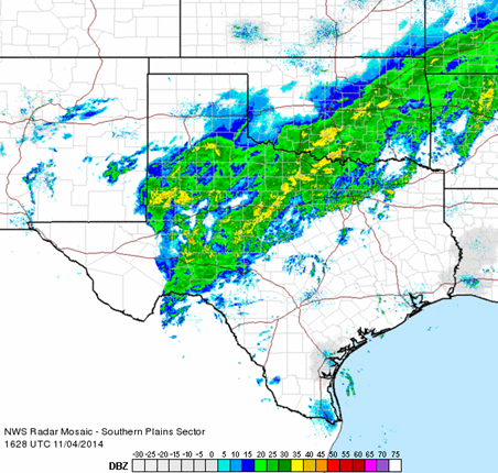
TEXAS RADAR at 10:45 AM -
[South Plains sector]
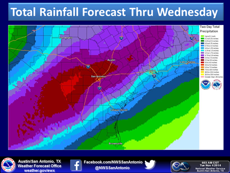
RAINFALL FORECAST -
[http://www.srh.noaa.gov/images/fxc/ewx/graphicast/image_full3.png]
______________________________
Lorenzo D. Sanchez, MPA, CEM
Director of Emergency Management
The University of Texas at San Antonio
University Police Department
Office of Emergency Management
One UTSA Circle
San Antonio, Texas 78249
Phone: (210) 458-6756
Fax: (210) 458-7602
Email: lorenzo.sanchez@utsa.edu<mailto:lorenzo.sanchez@utsa.edu>
Website: www.utsa.edu/utsapd<http://www.utsa.edu/utsapd>
Campus Alerts: http://alerts.utsa.edu/
[Description: cid:image001.jpg@01CD17CE.5E7D8A80]<http://www.utsa.edu/>[Description:
Facebook]<http://www.facebook.com/UTSAPoliceDepartment>[Description:
Twitter]<http://twitter.com/UTSA_Police>
From: Paul Yura - NOAA Federal [mailto:paul.yura@noaa.gov]
Sent: Tuesday, November 04, 2014 9:51 AM
To: Paul Yura - NOAA Federal
Subject: 930 AM Weather Update, Flash Flood Watch Expanded, begins at 6 PM tonight.
South Central Texas Partners...(Briefing graphics are attached)
...HEADLINE...
...Flash Flood Watch is in effect for all of South Central Texas from 6 PM tonight through
Noon on Wednesday...
...AREA OF CONCERN...
All of South Central Texas, but the highest totals as of right now are forecast along and
east of the I-35 corridor....including the Austin and San Antonio metro areas....and areas
south of Highway 90.
...IMPACTS...
· Flash Flood Watch in effect for all of South Central Texas for Tue 6 PM until Noon
Wednesday.
· Locally heavy rains of 2-4 inches, isolated totals of 7 inches.
· Highest totals along and east of I-35 corridor....south of Highway 90.
· High rain rates, in excess of 1-2 inches of rain per hour.
· Increased flows on creeks and low water crossings with some Flash Flooding possible in
both urban and rural areas.
· Some roads may become impassable.
· Thunderstorms with dangerous lightning and gusty winds.
...TIMING...
· Heaviest rainfall is expected from 6 PM Tuesday through 8 AM Wednesday....with highest
rain intensities from 8 PM Tue thru 4 AM Wednesday.
...CONFIDENCE...
Moderate-High
...DISCUSSION...
An approaching upper level storm system and cold front combined with increasing moisture
from the Gulf of Mexico and the Eastern Pacific will lead to widespread rains across South
Central Texas starting late Tuesday afternoon into Wednesday morning. A cold front will
move into the Hill Country this afternoon and will help to trigger lighter rainfall during
the day. As an upper level disturbance moves closer to Texas tonight, widespread heavy
rains are expected to break out across much of South Central Texas during the evening and
overnight hours. The slow moving cold front will be an added trigger for rainfall, while
the deep moisture will help produce high rain rates. Rain totals late Tuesday afternoon
through early Wednesday could reach into the 2-4 inch range, with isolated totals near 7
inches. Flash Flooding is a concern and thus we have issued a Flash Flood Watch for all
of South Central Texas starting at 6 PM tonight until Noon on Wednesday.
Wednesday morning will see the front and associated heavy rain start to shift east and
south into the Coastal Plains of Texas, mainly along and south of a line from Carrizo
Springs to San Antonio to Hallettsville. Lingering rainfall is still possible across the
I-35 corridor on Wednesday but the threat for additional heavy rain will be pushing south
and east.
Please keep "weather aware" over the next 24 hours as forecasts and the timing
of the front/upper level system are fine tuned. Most flash flood fatalities occur at
night while driving. If you don't have to be out this evening through the overnight
hours, stay at home. Remember...Turn Around...Don't Drown.
You can see the latest forecasts and watches/warnings/advisories by going to the
Austin-San Antonio National Weather Service website at
www.weather.gov/austin<http://www.weather.gov/austin>
--
Paul Yura
Warning Coordination Meteorologist
National Weather Service Austin-San Antonio TX
W:830-629-0130 ext 223
C:830-221-8565